Monday, October 7, 2013

Crater Lake, Oregon


 Crater lake from the gift shop parking lot looking southeast. (copyright 2009)
Dead tree stump at the western overlook of Crater Lake (copyright 2009)
Since we are on a volcano kick lets talk about one of the most famous volcanic craters in the United States. No not Yellowstone, Crater Lake, Oregon. You will never see water so blue. It is 1943 ft deep, which makes it the deepest lake in the United States and the 9th deepest in the world. [1] It is so clean and clear you can drink from it. How did this beautiful lake get there? It is a story of fire and ice and water.

The earth’s crust is not stable. It doesn’t sit in one place. It moves on a lake of molten lava and has several tectonic plates. These plates float and move from place to place, albeit, very slowly. The Pacific Ocean plate is pulling apart at the middle creating a rift zone that allows the molten earth beneath to ooze to the top creating volcanic islands like those of Hawaii. These volcanoes are not usually explosive but just pour the lava over the plate creating a “shield” volcano. At the shores of the Pacific the plates that are moving east and west from the rift get subducted beneath the continental plates that are denser than the oceanic plates. At the edges of these subduction zones explosive volcanoes form what is known as the Pacific Ring of Fire. Crater Lake sits in the eastern part subduction zone where the Pacific Plate is being subducted beneath the North American Plate.

The volcano that Crater lake sits in is named Mazama. It’s largest eruption happened at 7700 years ago and was probably the largest in North America for more than half a million years. After minor eruptions and a pause during the ice age that changed the consistency of the gases and molten rock beneath Mazama the Rhyolite in the core of the volcano mixed with water it became an explosive volcano known as a stratovolcano with many parasitic vents on its parameter. It isn’t the only stratovolcano in the area. It is part of a chain of volcanoes that is known as the Cascade Range that streatches from British Columbia to Mt Shasta in California.[2]

Mazama began growing over a half million years ago. At 8000 yag it stood at 12,000 feet. Then it blew with great force 7700 years ago. The ash from this explosion can be found as far away as Wyoming and Alberta Canada. It displaced so much ash from the insides of the volcano that the walls collapsed Mazama lost thousands of feet of mountain top in a span of a few short days. It didn’t stop erupting. Evidence of that is found within the Caldera in the form of Wizard Island and others that are under the water now. [3] Over several hundred years rain and snowmelt gathered in the deep Caldera which has no outlet or intake like many other lakes. Because of its depth and the clarity and cleanness of the water it is a deep azure blue. The water is completely replaced about every 250 years[4] Keeping the water in the lake is not a problem since it is in an area that gets large deep snowfalls. One of the pictures shown was taken in late May of 2011. The snow was so deep you had to stand on it to see the lake and the gift shop was hidden to the middle of the first floor with 4 foot basement walls below it. The heaviest snow fall occurred in 1971 was 37 inches. The average yearly snow fall is 488 inches or almost 41 ft. Per year and like most of Central Oregon you can see snow any time of the year with cold temperatures at night sometimes freezing even in July and August. [5]
Crater Lake in late May 2011 taken standing on about 20 feet of snow above the parking lot.

Can Mazam blow again? It is probable that it will become active as will many of the volcanoes of the Cascade Range since they are relatively young and many like Crater Lake show signs of geothermal activity. A submersible sent down to survey Crater Lake found such activity on the bottom of the lake.[6] It is not expected that it will be as large as the Caldera forming event and it won’t pose danger to areas below because the walls show no signs of collapse. However the mixture of rhyolite and water does make for an explosive combination. Earthquakes are another possibility in the area of up to a magnitude of 7 on the Richter scale.

If you come to Oregon in June, July or August seeing Crater Lake is a must. It is one of those places that qualifies as otherworldly in it beauty and geology. Check ahead for the weather since sometimes the lake is shrouded in fog and you won’t be able to see it if it is. Also if you can, try to get tickets for the boat tour. It will give you a much different view than from the rim. You also will get to visit Wizard Island in the lake. Crater Lake Oregon is truly a sapphire gem surrounded by the green emeralds of ponderosa pines. It is well worth the visit.


[1] http://www.nps.gov/crla/historyculture/index.htm

[2] http://www.nps.gov/crla/planyourvisit/upload/Geology.pdf

[3] http://www.nps.gov/crla/planyourvisit/upload/Geology.pdf

[4] http://en.wikipedia.org/wiki/Crater_Lake

[5] http://en.wikipedia.org/wiki/Crater_Lake

[6] http://travel.nationalgeographic.com/travel/national-parks/crater-lake-national-park/

Wednesday, September 25, 2013

Capulin Volcano

I have been away for a while with other pursuits.  You can see some of them at transcendentrunning.blogspot.com. But I am finally getting a chance to write for myself again.  Here is my newest installment.

 View from the rim trail Mt Capulin (copyright 2008)


You leave the flat Texas plains behind you and begin to move into a somewhat rolling area of green hills populated by deer, antelope and birds of prey. Soon after leaving Clayton, New Mexico behind, you begin seeing cone shaped mountains rise up out of the high desert floor and black lava flows on either side of the road. Up ahead there is a perfect shaped cone of a mountain. As you get closer you can see road encircling it. This is Mount Capulin. Standing as a sentry it guided those traveling the Santa Fe Trail.

The volcano rises 8182 ft above sea level and 1300 feet above the plains around it. The base of it is 4 miles around. The crater is 415 feet deep. Capulin got its name from the Spanish word for chokecherry. The plant grows prolifically on the slopes and in the crater. The area from Raton to Clayton New Mexico and up to the Colorado border is dotted with volcanoes. They make up a high ridge that was most inhospitable to the white settlers attempting the Santa Fe Trail. The volcanic field covers 8,000 sq miles from Trinidad, Colorado to Clayton New Mexico. Capulin was thought to have last erupted 60,000 years ago and was one of the most recent eruptions in the field. [1]

Capulin is a cinder cone. That means that the eruption was mainly of ash, rock and cinders that exploded upwards and then fell back to earth creating a cone. [2] The volcanoes of the area are considered dormant but it is believed that there could be an eruption at anytime though it is not anticipated in the near future.[3] The Capulin volcano is different from, say, Mount St. Helens because of its origins. Mount St. Helens sits on the boundary of a tectonic plate subduction zone; a place where the oceanic plate is sliding beneath (subducted) the North American Continental plate. Most of the volcanoes along the Pacific Ring of Fire are this type of volcano. However, the Capulin volcano is considered a “hotspot” volcano. Volcanologists recognize only 49 volcanic "hot spots" in the world. A few other famous volcanic hot spots include the Azores, Reunion Island, Iceland, Hawaii, and parts of East Africa[4] These volcanoes are basaltic in nature rather than rhyolitic. Basaltic volcanoes are less explosive than those that contain rhyolite which becomes very explosive when water is added to the mixture.[5] The Yellowstone volcano started out as a Rhyolitic volcano and had one of the largest eruptions every known on earth. But once the rhyolite is spent as with Yellowstone, lesser eruptions can occur if the volcano sits over a hotspot with molten basalt rising through lithospheric fissures. These fissures continue to provide molten material over a long period of time. Tuzo Wilson, the Canadian geophysicist who discovered, the "hotspot" theory, believed that as the tectonic plate moves the volcano that has been erupting moves beyond the hotspot, another volcano begins to erupt behind the former one creating a chain of volcanoes now lead by extinct volcanoes. Hotspots are long-lived so they may create many successive volcanoes.[6] You see this with Hawaii where the younger island is to the south east and the older islands are located at the top of the chain. You can follow a trail of older volcanoes to the west of Yellowstone through Idaho and Oregon.[7] The Capulin Volcano is believed to be part of the Yellowstone hotspot. [8]

As you stand at the top of Capulin you get a bird’s eye view of this kind of volcanic history. Visiting Mt Capulin is easy. You just drive right up the road to the rim of the crater. It is an easy walk down into the crater. At the right time of year you will find chokecherries on the bushes that have grown up inside and along the volcanoes sides. There are many birds, especially humming birds in the area along with crows and birds of prey circling above. The rim trail is a longer trail. Make sure to heed the signs of snakes in the area. I did not see any rattle snakes but was chased by a non-poisonous snake that was very aggressive. I was merely walking down the rim trail and a couple was walking up and had scared the snake. It felt my heat signature and made a bee line for me. I moved backwards very quickly and it veered off at the last minute. Make sure that you take water with you since it is fairly warm and protected inside the crater and there is no water at the trail head. Also make sure you have gas in your car before you head up the mountain since there are no gas stations in Capulin. There is no camping inside the park. You will find a very small rv park in Capulin. [9]

Make sure to take your camera to capture the breathtaking views. Have fun!


[1] http://www.nps.gov/cavo/naturescience/index.htm
[2] http://www.nature.nps.gov/geology/parks/cavo/
[3] http://www.ohranger.com/capulin-volcano/geology
[4] http://www.cimarronnm.com/PDF/Capulin%20Volcano.pdf
[5] Alt, David and Hyndman, Donald W, Roadside Geology of Oregon, Mountain Press Publishing Company, copyright 1978
[6] http://pubs.usgs.gov/gip/dynamic/hotspots.html
[7] http://en.wikipedia.org/wiki/Hotspot_%28geology%29
[8] http://en.wikipedia.org/wiki/Hotspot_%28geology%29
[9] http://www.nps.gov/cavo/planyourvisit/index.htm

Monday, August 26, 2013

Dubois, WY


Badlands neat Dubois, WY (copyright 2009)

Dubois (Do, Boys) Wyoming is located on highway 26 close to the entrance to the Wind River Canyon in northwestern Wyoming. The area is surrounded by the Wind River and Absaroka Mountains and to the east by the badlands pictured here. It is called an “authentic western town” on the Dubois web page[1] The rustic log buildings along main street are much the same as in the 1800”s when the town was formed. The Wind River quietly runs through the town toward its destination of the Yellowstone.[2]

Dubois has a colorful history. American Indians lived on the land before whites settled there. The first known inhabitants were the Sheepeaters of the Mountain Shoshone Indians. The Wind River area was part of their annual migration route. You can still see petroglyphs and stone tipi circles in the Dubois area. [3] Early on French and British fur traders walked the rivers of the area trapping furs to be sent east and on to Europe. The first European trappers were Francois and Louis Verendrye in 1742–43. After them came Astorians who later established fur trade at the mouth of the Columbia River in Oregon territory. Mountain man Jim Bridger passed through the area in 1807 on his way to the Yellowstone.[4]

Then in the 1870’s came homesteaders who decided not to go on over South Pass to Utah or Oregon. Lumber was the main industry early on.[5] You can still see remnants of the tie hacks that worked there to fell the trees and create ties for the railroads. Though the actual buildings have been destroyed by time there is still glass, turned purple by the sun and age, from some of the buildings and you can find cross cut saws and axes and other artifacts of the tie timber industry.[6] The town even has ties to Butch Cassidy who, in 1890 prior to his infamous crime spree, owned and managed a ranch outside of town.[7] In 1886 the people wanted to call their town “Never Sweat.” There are two interpretations on why they wanted to name it that. One says that it was a joke because the men didn’t take work so seriously and never sweat.[8] Another is because of the dry Chinook winds that grace the area no one ever sweats.[9] However, the US Postal Service, in its infinite wisdom, decided that was not an appropriate name for a town and named it after an Idaho senator,[10] Senator Fred Thomas Dubois (1851-1930), a member of the Postal Committee. [11]

The geology of the area is one of its main attractions. The Dubois Badlands is located in Fremont County, about 2 miles east of of Dubois. Access is from a county road on the western boundary. [12] These are made of alluvial deposits from the Wind River made up of Sandstone and Mudstone. Conglomerate in the formation is from algae fossils that formed in ponds about 55 million years ago. These formations have light vegetation like a high desert. Cottonwoods grow in the deeper canyons along streams. There are no official trails through the badlands, but you can follow stock trails through the Mason Draw area. These beautiful formations are in danger from housing developments to the west and also from oil and gas development on their fringes.[13]

Dubois offers many recreational opportunities. You can visit the National Bighorn Sheep Interpretive Center and learn about the large herd in the area. The Dubois Museum provides a look into the history of the area. Dubois is home to many who work in the arts and has a 17,000 sq ft facility known as the Headwaters Community Arts and Conference Center. There is the Tie Hack Memorial that recognizes the Scandinavian Tie cutters who worked in the area supplying ties to the CB&Q railroad. It is located northwest of Dubois on highway 26/287. Rodeo and square dancing are held during the summer for those who would like to get a real look at western life. The area also offers camping, hunting in season, hiking and rock hounding. [14]

[1] http://www.duboiswyoming.org/
[2] http://en.wikipedia.org/wiki/Dubois,_Wyoming
[3] http://en.wikipedia.org/wiki/Dubois,_Wyoming
[4] http://en.wikipedia.org/wiki/Dubois,_Wyoming
[5] http://www.duboiswyoming.org/aboutdubois.html
[6] http://www.duboiswyomingchamber.org/see.html
[7] http://en.wikipedia.org/wiki/Dubois,_Wyoming
[8] http://www.duboiswyomingchamber.org/
[9] http://en.wikipedia.org/wiki/Dubois,_Wyoming
[10] http://www.duboiswyomingchamber.org/
[11] http://www.wyomingtalesandtrails.com/dubois.html
[12] http://www.wildwyo.org/Dubois_Badlands.html
[13] (Movlar, Eric,
[14] http://www.duboiswyomingchamber.org/do.html
Wild Wyoming, Flash Floods, Badwater, p143-148: Globe Pequot Press; copyright 2001, A Falcon Guide)

Monday, August 12, 2013

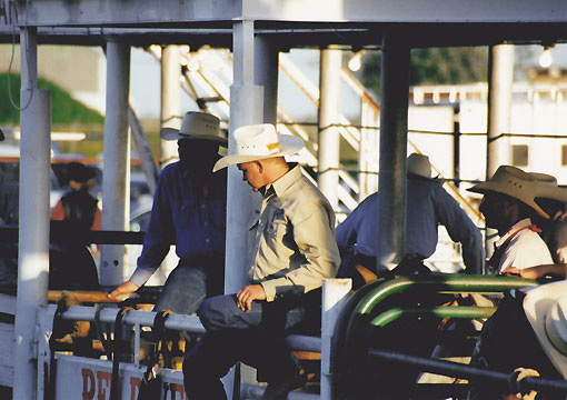
Top of Texas Rodeo, Pampa, Tx


 "The Chutes" at the Top O'Texas Rodeo (copyright 2000)
Presenting the Colors (copyright 2000)

I remember when my Dad introduced me to my new family when I was 13 years old after my mother had died two years earlier. We would be moving from South Denver, Colorado to Littleton where my new step family lived. I suddenly gained 3 brothers and a sister in the deal. I would be the youngest. My biological mother had loved to paint. Her favorite topic was horses. She loved horses and so did I. I always wanted a pony, but living in the big city meant that wasn’t possible. So I thought it was really cool when we moved to Littleton on the little acreage and I met my brother Dale. He was a real rodeo cowboy. I got to exercise his horses for him and sometimes help out with moving cattle around in our arena when he practiced roping. I got to attend rodeos like the Greeley Independence Day Stampede where I sat on the chutes with the performers.

Rodeo type competitions have been around for a long time. They may date back to the Greeks and Minoans where bull wrestling and bull jumping was practiced. The American version probably came from Spain. As the Spanish Conquistadores moved up into the southwestern United States on their explorations of the New World they brought with them their horses and cattle and their ways of handling the stock. These had developed from the sports of Spanish bull fighting and cattle wrangling. The vaqueros had rodeos of sorts but they didn’t look like the American version of today. [1]

American rodeo started from everyday ranching activities such as roping calves that strayed from the herd or for branding and taming horses.[2] In Texas with its extensive grasslands cattle were fed and then herded long distance to market in large cattle drives. Some of the names are familiar especially to those in the Texas Panhandle, names like John S. Chrisom, Oliver Loving, and Charles Goodnight. Young men began to join these cattle drives and the American cowboy was born. As the railroads were builto into the southwest it became much more profitable to keep cattle on large ranch holdings where they didn’t have to make the arduous trip to market. This meant they remained fatter and brought more money when sold. The cowboys of the trail drive settled on ranches such as the XIT of the Texas Panhandle. As is the case when a bunch of guys get together they decided to compete with each other during their off time. They competed in the skills that they had acquired on the trail and on the ranches and the American rodeo was born.[3] Soon the competitions began to spread and at the same time Wild Bill Cody started his Wild West Show exhibiting western lifestyles to the people of the east and mid west and even Europe. Rodeo type exhibitions and the Wild West shows went hand in hand. Rodeo and anything “western” was exciting for people of the east coast[4]

After WWI rodeo became even more institutionalized. Madison Square Garden put on a rodeo in 1922 overshadowing Cheyenne Frontier Days which had been the premier rodeo to that point. In the early 1930s rodeo associations were formed to govern events and to make sure that cowboys were paid fairly. To that point some promoters took advantage of the performers and kept more of the prize money than they handed out. Many rodeos claimed to be the “championships,” which caused a lot of confusion. In 1958 the National Finals Rodeo was started, giving rodeo a national TV audience. Rodeo had joined the world of big business and big media. The NFC has been held in Las Vegas, Nevada since 1985.[5] The history of rodeo is much more extensive than covered here. There are many venues, Omak Stampede, Greeley Stampede, Pendleton Roundup and Cheyenne Frontier Days to name just a very few.

The pictures here were taken at the Top of Texas Rodeo in Pampa, Texas in the northern part of the Texas Panhandle in 2000. This rodeo was started when some Pampa businessmen were meeting for coffee and decided it would be a great idea to provide some kind of entertainment for the people of Pampa. It made sense to let the cowboys and girls of the area show off their skills. The Top O’ Texas Rodeo Association was born. This rodeo has been held annually since then except for 1970 and 71. In 1970 a tornado tore apart some of the stands in the arena and in 71 there was quarantine on Panhandle livestock do to Venezuelan Equine Encephalomyelitis. [6]

The city of Pampa is the second largest city in the Panhandle. It was built up due to oil and its allied industries and became a market center for agriculture and livestock.[7] The Santa Fe Railroad was constructed through the area in 1888. A train station and telegraph office as built and the town site established by George Tyng who was he manager of the White Deer Lands ranch. People settled and developed the land sold by Timothy Hobard. Gas and oil were discovered in the Panhandle in 1916 and in the resulting oil boom Pampa prospered. In 1928 it became Gray County seat. [8]


[1] http://en.wikipedia.org/wiki/History_of_rodeo

[2] http://en.wikipedia.org/wiki/History_of_rodeo

[3]http://www.tshaonline.org/handbook/online/articles/llr01

[4] . http://en.wikipedia.org/wiki/History_of_rodeo

[5] http://en.wikipedia.org/wiki/History_of_rodeo

[6] http://topoftexasrodeo.com/

[7] http://www.cityofpampa.org/